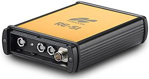
Topcon RE-S1 GPS
Topcon is pleased to announce the versatile RE-S1 1 watt radio extension system with field-proven, 915+ technology. The RE-S1 can be utilized as a transmit/receive external 915+ radio with any Topcon receiver or as a stand-alone repeater to increase range between base and rover.
Features Include:
1 watt transmitting power for long range communication between base and rover receivers
Repeater mode allows operational range to be extended
Compatible with any Topcon GNSS receiver and supports all products with 915+ radio technology
No FCC licensing required
Can be used as mobile repeater with optional car lighter adapter
Physical
RE-S1
Enclosure Aluminum
Dimensions W:145 x H:110 x D:35 mm
Weight 0.4 kg
Antenna External
Battery External (no internal power source)
Controller External
LEDs One LED: RX TX – modem status
Communication I/O
Communication Ports Two high speed RS232 serial ports
Port specifications RS232 Serial Port
Baud rate: 460800,230400,115200(Default),57600,
38400,19200,9600,4800,2400,1200,600, 300
Flow control: RTS/CTS
Length: 7,8 (default)
Sop bit: 1 (default), 2
Parity: None (default), Odd, Even
Connectors Modem Antenna (reverse polarity TNC), PWR, RS232
MINTER One LED (see “LEDs” on page 9 for details)
Antenna Type
Type 1/2 wave articulating whip
Connector Reverse polarity TNC
Gain 2.5 dBi
Modem and Connector
Modem Spread Spectrum
Type Reverse polarity TNC
Signal Type Modem I/O
Dir I/O
Details RF/GSM output from modem antenna
environmental
Operating temperature 40 C° to +55 C°
Storage temperature 40 C° to +75 C°
Humidity 95%
Performance
General Modem Details
Frequency Range country/region/purpose dependent 902 to 928 MHz, United States 915 to 925 MHz, Australia
Signal structuring Frequency-hopping spread spectrum
Hopping pattern 5 per band, user-selectable
Hopping channels 128
Occupied bandwidth 100 KHz
Frequency modulation technique FSK, 64 Kbps
System gain 29 dB
Operation mode Transmitter, Receiver, Repeater
Protocol FH915, FH915+
Data Communications
Serial interface RS232
Serial data rate 9600, 19200, 38400, 57600 bps, user selectable
Effective radio link rate 9600, 10200, 17000, 51000 bps User selectable for FH915; automatic selection for FH915+
Error correction FEC (15.7), majority decoding
$
650.00
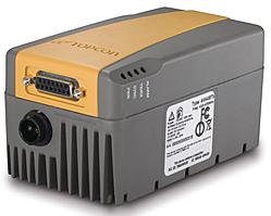
Topcon TRL-35 Radio
The new TRL-35 digital 35 watt UHF radio represents the next generation of radio design for RTK communications. By utilizing DSP technology and advanced digital design, the TRL-35 delivers greater reliability than previous UHF radios and sets new standards for performance and innovative design.
Don't let the small size fool you. Within it's compact case the TRL-35 packs a powerful punch-35 watts of clean, penetrating, digital power! Just take a look at some of the outstanding features of the TRL-35, features that far exceed all of the competition!
TRL-35 Features:
100% digital radio delivers longer range in difficult conditions than older UHF technology
Incredibly small size! Only 6" x 2.9" x 2.8" (HxWxD)
Paccrest PDL and Trimtalk compatible
Jobsite tough… 100% dustproof and rainproof with IP66 environmental rating!
Wide frequency range of 410MHz to 470MHz with programmable bandwidths
Compatible with HiPer+, HiPer XT, and GR-3 UHF integrated rover receivers and all Topcon RTK base receivers
Physical
TRL-35 General
Dimensions 6” L x 2.9” W x 2.8” D
Weight 27 oz
Power Supply Voltage +9 to +16 Vdc nominal
Power Consumption (Average) 120W/38W/300mW – Continuous Transmit/Transmit with 30% Duty cycle/Sleep
Antenna Connector TNC, 50 Ohms
User Interface Connector DB-15 waterproof, female connector
Power Connector Alden products pulse lock two pin connector
$
990.00
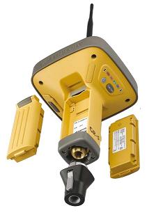
Topcon GR-5 GPS Receivers
Topcon is proud to be the world leader in advanced satellite positioning technology. As the original pioneer of dual-constellation and G3 triple-constellation integration, Topcon continues to lead all other manufacturers with the most sophisticated receiver technology and design.
One look at the GR-5, and you notice the advanced antenna design. This patented Fence Antenna™ technology provides industry-leading tracking sensitivity and multipath rejection in a compact and lightweight package. By combining this antenna with the latest innovations in tracking algorithms, Topcon has given the GR-5 our most highly advanced tracking performance ever!
The GR-5’s tracking capabilities are not only state-of-the-art, but also deliver unmatched value to our customers by providing accuracy levels superior to other RTK systems in difficult environments. While other systems sacrifice accuracy for tracking performance, the GR-5 gives you the best of both! The GR-5's design didn’t stop simply with new antenna and tracking technologies, it also boasts numerous advancements such as: an increased number of channels, extended battery life, expanded internal memory options, new internal modem design, internet-compatible firmware, MAGNET software capable and much, much more. It all sums up to… More Performance. More Accuracy. More Productivity.
Features:
216 Universal Tracking Channels
G3 Tracking Technology (GPS/GLONASS/GALILEO)
Advanced Fence Antenna™ Technology - Unsurpassed tracking and performance
Sophisticated, High Accuracy RTK technology with position updates up to 100Hz
Integrated Dual Communication System with multiple Radio and Cellular combinations
MAGNET software compatible
32GB SDHC storage support
Dual hot-swappable batteries
Specifications
TRACKING
Number of Channels 216 Universal Channels
Signals Tracked G3 Technology – GPS, GLONASS and GALILEO*
WAAS/EGNOS/MSAS
WAAS/EGNOS/MSAS Yes
ACCURACY
RTK H: 10 mm + 1 ppm
V: 15 mm + 1 ppm
Static/Fast Static H: 3mm + 0.5ppm
V: 5mm + 0.5ppm
COMMUNICATIONS
Optional Radio Type Integrated UHF TX/RX, or 915MHz Spread Spectrum
Base Radio Output 0.01 - 1.0W, user selectable
Cellular Communications Integrated GSM/GPRS or CDMA****
Wireless Communications Integrated Bluetooth® 2.0 compliant
DATA & MEMORY
Memory Internal, Removable SD/SDHC Memory Card
Data Update/Output Rate 1Hz – 100Hz Selectable***
Real Time Data Output TPS, RTCM SC104, CMR, CMR+
ASCII Output NMEA 0183 version 2.x and 3.0
ENVIRONMENTAL
Enclosure Magnesium I-Beam Housing
Operating Temperature -40 to +70°C**
Dust/Water Protection IP66
Shock Rating 2 meter pole drop to concrete
IEC 60068-2-29, IEC 60068-2-27
Vibration Rating SAE J1211, Section 4.7
MIL-STD 202G, Method 214A
$
6,266.00
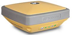
Topcon HiPer II GPS Receivers
Topcon raises the industry standard once again by presenting the next-generation of the world’s most popular receiver system –the HiPer II. Smaller, lighter, faster, more affordable: the HiPer II receiver is designed on these clear-cut concepts. This state-of-the-art receiver not only offers further enhanced agility, but also increases receiver performance and user-friendliness as well as the fully customizable structure providing our customers with the maximum flexibility to choose the system options they require.
Features:
Smaller. Lighter. Faster. More Affordable.
Integrated GPS+GLONASS RTK & Static Receiver
Rugged, Lightweight, Magnesium Alloy Construction
Cable-free Bluetooth® Wireless Operation
Optional integrated SS or Digital UHF Radio
Optional integrated GSM or CDMA Modem
Bright, easy-to-read LED Panel
Voice Messages for Receiver Status
SD/SDHC Memory Card Slot
Removable Li-ion Battery
Internal GSM/CDMA Modem for Network RTK
Designed as a perfect network RTK rover, the HiPer II gives you the option of an internal GSM or CDMA cellular modem. With its completely integrated design, the HiPer II eliminates the hassles of external modems and cables, all in a lightweight, rugged design.
Voice Messages for Receiver Status
Multi-lingual, clear-tone voice messages notify the users of critical receiver information and status such as satellite signal interruption, radio interference, low battery, low memory and more. This feature improves your efficiency by providing information without having to look at the LED display or controller screen.
Long-Life Li-ion Battery
Topcon's HiPer II comes standard with a modern design long-life Lithium Ion battery that is located safely behind a sealed battery cover.
Data Storage with SD or SDHC Cards
A large volume of static observation data from long term survey projects, long sessions and displacement monitoring can be stored onto the popular SD cards or SDHC cards with 4GB or larger capacity.
TopSURV 8 Field Controller Software
The easy-to-navigate, intuitive user interface of TopSURV software offers all users its full functionality with the shortest learning curve. TopSURV supports all surveying tasks including topo data collection, as-built survey and stakeout.
Topcon Tools Complete GNSS Data Management & Post Processing Software
The powerful Topcon Tools software suite completes the full Topcon field-to-finish GNSS solution. With comprehensive data manipulation, processing, and analysis, Topcon Tools unlocks the full power of the Topcon GNSS systems solution.
$
7,433.00
Topcon HiPer SR GPS Receivers
Topcon's premier GNSS receiver in a smart, compact, ultra-rugged GNSS receiver.
Lightweight yet tough enough to survive a 2m drop, and enough rechargeable batter for 20 consecutive hours of operation! Topcon's HiPer SR integrated receiver operates cable free, with no antennas, battery doors, or connectors. HiPer SR features the 226 channel, universal tracking capable Vanguard chip for unmatched performance flexibility to meet the needs for all jobs, large or small. Use a single SR for fast and accurate static GNSS or as a network RTK by adding network functionality and cellular enabled controller. Use a pair for an economical base and rover RTK solution or with Topcon's LongLink communication solution for the perfect small site-wide solution. The best part? There's a HiPer SR to fit your budget.
Power. Performance. Price. With the HiPer SR, it all fits in the palm of your hand.
Features include:
Vanguard chip technology featuring 226 Channels with Universal Tracking
Compact, lightweight, rugged design
Completely integrated receiver, antenna, batteries, memory, and communications
Integrated multi-channel LongLink™ communication technology
Sealed battery providing up to 20 hours of operation
4GB onboard memory (Firmware limit of 2Gb for static data)
Reduced MINTER display, with single-button operation
Charging (serial and power) and USB ports only.
Specifications
Tracking
Number of Channels 226 Channels
Signals Tracked
GPS: L1 C/A, L1, L2P(Y), L2, L2C code and carrier
GLONASS: L1 C/A, L1P, L2 C/A, L2P code and carrier
SBAS (WAAS/EGNOS/MSAS) L1 code and carrier
QZSS L1 code and carrier
Galileo1
Antenna Type Integrated Antenna w/ internal ground plane
Technology Quartz Lock Loop, Intelligent Tracking Optimization
Topcon AMR, Universal Tracking Technology
Topcon AFRM
Positioning Accuracy*
RTK (L1+L2) H: 10 mm + 1.0 ppm; V: 15 mm + 1.0 ppm
Static Fast Static (L1)
H: 3 mm + 0.8 ppm; V; 4 mm + 1.0 ppm
Fast Static (L1+L2)
H: 3 mm + 0.5 ppm; V:; 5 mm + 0.5 ppm
Kinematic (L1, L1+L2)
H: 10 mm + 1.0 ppm; V: 15 mm + 1.0 ppm
DGPS < 0.4 m
SBAS < 0.6 m
Autonomous < 1.2 m
Maximum Data Rate 20 Hz
Communication
RTK Broadcast LongLinkTM 300m+ Range,
Maximum of 3 simultaneous rovers
Bluetooth® Yes
Serial Yes
USB Yes, Client
Data & Memory
Memory 4GB internal (non-removable)
Real Time Data Output TPS, RTCM SC104 v 2.x, 3.x; CMR/CMR+
ASCII Output NMEA 0183 version 2.x and 3.0
Physical
Dimensions 150 (W) x 150 (D) x 64 (H) mm
6 (W) x 6 (w) x 1.5 (H) inch
Weight 850 gms, 1.87lbs
Status Display / Panel MINTER
External Power Connector Yes
Power Supply
Operation Time Up to 20 hours
Environmental
Operating temperature -20ºC to +65ºC with internal batteries
-40ºC to +65ºC without internal batteries
(external power)
Storage temperature -40ºC to +70ºC
Humidity 100%, condensing
Water & Dustproof rating IP67 (1 meter submersion, fully dustproof)
1 Support for Galileo will be incorporated into HiPer SR when the constellation has matured and is ready for commercial use.
$
2,650.00
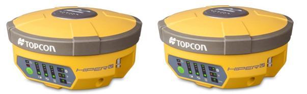
Topcon HiPer V GPS Receivers
Compact, cable-free solution with Vanguard Technology for all GNSS positioning applications.
In a continued commitment to improving the productivity of positioning professionals, Topcon enhances the HiPer family of products by adding Vanguard Technology to the HiPer V. In the early 2000’s Topcon revolutionized GNSS receivers by integrating the design to be compact and light weight. Topcon continues the revolution with Vanguard technology.
Features:
Vanguard Technology
226 GNSS Channels
Rugged, Magnesium Alloy Construction
Integrated RTK and Static Receiver
Fence Antenna Advanced Performance
Topcon raises the standard once again by adding Vanguard Technology’s 226 channels and fence antenna into a versatile, configurable receiver, HiPer V. The additional channels and precision antenna element make RTK positioning faster and more productive than any other receiver on the market.
$
8,390.00
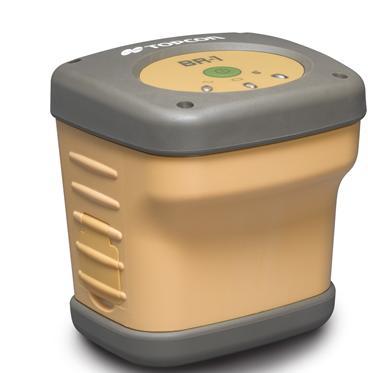
Topcon BR-1 Hand-held Devices
Topcons GMS-2 features standard WAAS or EGNOS positional correction augmentation. These satellite based signals provide extensive coverage throughout the US and Europe and provide the GMS-2 with off-the-shelf real-time sub-meter accuracies. However WAAS and EGNOS satellite signals can susceptible to sporadic or blocked signal reception in shrouded areas such as tree canopies, around tall buildings, or near other large obstructions. There is another option for real-time correction - Topcon's wireless BR-1. The BR-1 provides access to free radio-based, real-time Coast Guard Beacon correction signals. For over 10 years Coast Guard Beacon signals have been providing reliable, real-time data to improve positional accuracies for coastal and inland waterway navigation across the US and Canada. Widely accessible throughout North America, these signals can be used as a viable alternative to WAAS correction signals for data collection, navigation, and other field applications. The advantage? Coast Guard Beacon signals are land-based terrestrial radio signals, much less susceptible to interference and blockage, making them the perfect correction signal alternative for your GMS-2. The BR-1 has four tracking channels allowing it to monitor simultaneous beacon signals and automatically utilize the best correction available.
BR-1 features:
Lightweight, compact and easy-to-use
4 tracking channels
Hot swappable battery with GMS-2
Bluetooth Wireless Communication
1 meter drop warranty
IP66 Rugged for rough field use
Adding a BR-1 to your GMS-2 or GMS-2 Pro receiver couldn't be easier. Integrated Bluetooth® wireless communication means no cables or connectors! The wireless BR-1 integrates an internal li-ion battery that provides 15 hours of continuous field use, and is user replaceable and rechargeable. The included protective soft case lets you carry the BR-1 on your belt or backpack strap, and features a clear acrylic window allowing for at-a-glance signal reception/GMS-2 communication verification. Color LED's indicate Bluetooth wireless connection status, battery status, and beacon signal reception. There's even a serial port for flexibility to connect to other GPS receivers or to a PC for firmware updates.
Whether you find yourself out of range of WAAS or EGNOS signals on a regular basis, experience weak or intermittent correction signals, or you're just looking for an alternative to help streamline work flow and eliminate post-processing back in the office, Topcon's new BR-1 Beacon receiver is your answer.
Specifications
Tracking
Signal Coast Guard Beacon
Channel 4
Physical
Dimensions W112xD101xH122 mm
Weight .79 kg
Color Topcon Yellow/Grey
Environmental
Operating Temperature -20° to +50° degrees Celsius
Storage Temperature -30° to +60° degrees Celsius
Waterproof IP66
Drop 1 m
Power
Internal Battery Lithium-ion 7.4V 2200mAh; repeatable
Operating Time No less than 15 fully charged Hours
Input Voltage 8 to 15 V DC, 12 to 15 minimum charge
Battery Charger yes
Charging Time ~3 Hours
Communication
Bluetooth standard 1.2; Class 2; Profi le: SPP
Serial Port RS232 port, 300-115200 Baudrate, RTC/CTS Flow Control, N/A, N/A, N/A
Key and LED
Key Power On/Off
LED 3: Bluetooth wireless connection status,charge level, receiving status
$
625.00
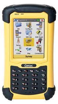
Topcon FC-236 Field Controller Hand-held Devices
FC-236
Features:
MIL-STD-810G and IP67 Compliance
Microsoft Windows Mobile®
Marvell PXA310 806MHz processor
Integrated Bluetooth® wireless & 3.5G Cellular connectivity
Highly rugged design
Embedded High Sensitivity GPS Receiver
3MP Autofocus Camera
Rugged and Compact
Topcons FC-236 is a fully rugged handheld built to meet MIL-STD-810G with high-speed HSDPA wireless networking, designed for dependability under the most extreme weather conditions, environments, and everyday use.
Integrated Sensors
Embedded 20 channel all-in-view tracking SiRF Star III chipset provides positional information by point positioning or by DGPS using SBAS corrections. The FC-236 incorporates a 3MP Autofocus Camera, electronic compass and an altimeter for GIS data collection applications.
Easy, Intuitive Operation
Windows Mobile 6.1 operating system and a 3.5” sunlight readable touch screen display provide quick, easy, and intuitive operation.
Specifications
COMPUTER
CPU 806MHz
OS Microsoft Windows Mobile® 6.1
Memory 256MB NAND Flash and 4GB iNAND
Display 3.5” VGA (480 x 640 pixel), Transflective sunlight readable display, Pressure sensitive touchscreen
Keypad Soft input panel (SIP) on screen keyboard
Interface Wireless LAN 802.11 b/g
Bluetooth® (v2.0 +EDR Class 2)
USB Type Mini-B (Host 1.1/Client 2.0, to be switched by software)
SD/SDHC Card Slot (Up to 16GB SDHC)
INTEGRATED SENSOR
GPS Type SiRFstarIII Chipset, GPS L1 (C/A), 20 Channels
Horizontal Accuracy (RMS)*1 DGPS*2: 1m to 3m (3.3’ to 9.9’), Point Positioning: 5m (16.4’)
Built-in Camera 3 Megapixels, Autofocus Camera
Other Sensor Electronic Compass, Altimeter
ENVIRONMENTAL
Dust/Water Protection IP67
Operating Temperature -22°F to 140°F (-30°C to 60°C)
Temperature Shock MIL STD-810G, Method 503.5, Procedure-I-C; -30˚C~71˚C
MIL-STD-810G Drop 5’ (1.52m), Vibration, Humidity; Tumble spec: 1,000 1.6 ft/0.5m tumbles (2,000 drops)
PHYSICAL
Dimensions H 7” x W 3.5” x D 1.18” (H 178 x W 89 x D 30mm)
Weight with Battery 17.64 oz (500g)
Battery Removable Li-ion Rechargeable Battery, 3.72V, 5600mAh
Operating Time 7.5 hours with Bluetooth® connection
Recharging Time 3.5 hours
$
3,100.00
Topcon FC-25/FC-25A Field Controller Hand-held Devices
Features
Windows Mobile® 6.5
Embedded 20 Channel GPS Receiver
WLAN/Bluetooth® Wireless
533MHz CPU / 256MB SDRAM
Field-exchangeable Li-ion Battery
Rugged and Lightweight (11.3 oz.)
IP65 Dust/Water Protection
FC-25A also with Built-in Camera, Compass, and Altimeter
Specifications
COMPUTER
CPU 533MHz
OS Microsoft Windows Mobile® 6.5
Memory 256MB SDRAM, 2GB Flash Memory
Display 3.5" Sunlight Readable TFT color LCD 640x480 VGA with Touch Screen
Keypad 4 keys (including power key) and 1 directional key
Interface Wireless LAN 802.11 b/g Bluetooth® Ver.2.0 Class 2USB Type Mini-B (Host 1.1/Client 2.0, to be switched by software)SD/SDHC Card Slot (Up to 16GB SDHC)
INTEGRATED SENSOR
GPS Type SiRFstarIII Chipset, GPS L1 (C/A), 20 Channels
Horizontal Accuracy (RMS)*1 DGPS*2: 1m to 3m (3.3’ to 9.9’), Point Positioning: 5m (16.4’)
Built-in Camera (FC-25A) 3 Megapixels, Auto Focus Camera
Other Sensor (FC-25A) Electronic Compass, Altimeter
ENVIRONMENTAL
Dust/Water Protection IP65 (IEC 60529:2001)
Operating Temperature -22°F to +140°F (-30°C to +60°C)
Temperature Shock MIL STD-810G, Method 503.5, Procedure-I-C; -30˚C~71˚C
Humidity Up to 95%, non-condensing
MIL-STD-810G Drop 5’ (1.52m), Vibration, Humidity
PHYSICAL
Dimensions H 5.75” x W 3.23” x D 1.30” (H 146 x W 82 x D 33mm)
Weight with Battery 11.3 oz (320g)
Battery Removable Li-ion Rechargeable Battery, 3.7V, 2400mAh
Operating Time 7.5 hours with Bluetooth® connection
Recharging Time 3.5 hours
$
560.00
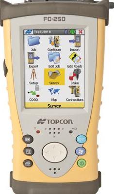
Topcon FC-250 Field Controller Hand-held Devices
Compact, ruggedized, hand-held, Windows Mobile 6.5, field controller
806MHz Processor
Windows Mobile 6.5 operating system
Live video capable - perfect for use with Topcon's IS Imaging Total Station
RS-1 Radio capable
Compact, ruggedized design
Easy access Compact Flash and SD Media card slots deliver memory expansion and connectivity options
Built-in Bluetooth® wireless technology and WiFi
Removable Li-ion batteries
Ultra-bright, TFT, color touch screen display
Topcon's FC-250 - The compact controller for big-time results Design
Ultra-bright, TFT sunlight-active, color touch screen display
Wireless connectivity available for Topcon GPS+ and W-series total stations
Cable-free operation
Durability
Ruggedized, shock absorbing environmentally sealed housing
Separately sealed battery makes swapping a snap
Shock Resistance, 1 meter drop resistant
Compact, Ruggedized Design
The FC-250 field controller incorporates Windows Mobile® 6.5 operating system on a crisp, bright, color touch screen display that makes your field data come alive. This powerful operating system, combined with the versatility of dual removable media for data storage and transfer; the easy-access, long-life rechargeable battery; and the compact design that is small on size, but not in performance, makes the FC-250 the perfect field controller for any job.
Easy Access Compact Flash and SD Media Card Slots
Extra memory cards can be placed into the protected card slots easily. No tools or extra process needed to access the card slots. Utilize SD or CF cards for data transfer and exchange with other devices.
Removable Li-ion Batteries
The small yet powerful battery is designed for quick replacement while in the field. A second battery can be charged externally as backup.
Built-in Bluetooth and WiFi
The FC-250 has built-in Bluetooth® wireless technology and WiFi. Both the Bluetooth and WiFi components are hardwired inside the device leaving the CF card slot open and available for other CF devices.
$
3,100.00
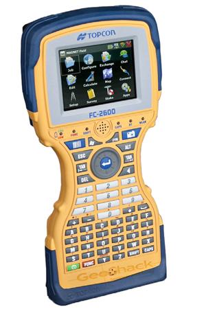
Topcon FC-2600 Field Controller Hand-held Devices
Rugged by design! Windows CE6, full-featured keyboard, ruggedized, handheld field controller packed with memory and built-in 5 megapixel camera.
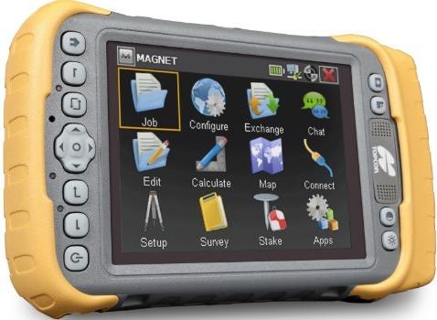
The FC-2600 is a great field controller to run Magnet Field software. The very bright transreflective screen makes it the best sunlight readable screen on the market. Use the FC-2600 as a robotic and RTK GPS controller.
LongLink – The FC-2600 has a very long range to a LongLink enabled device such as the ES, OS, PS total stations. In field tests, we have seen distances farther than a 1000 feet.
Use a MyFi device to connect your FC-2600 to an internet connection in the field. When connected, the cloud exchange functionality of Magnet is fully realized.
FEATURES & BENEFITS:
624MHz XScale processor
5.17 megapixel camera and bar code reader
2Gb ROM
Built-in wireless Bluetooth and WiFi connectivity
Windows CE.NET 6.0 operating system (Support Magnet Field)
55 key alphanumeric keyboard
Specifications
General Specifications
Microprocessor Xscale PXA 270
Processor Speed 624 MHz
Operating System CE.NET 6.0
Memory 256MB SDRAM
2GB System FlashDisplay
Display Resolution 320 x 240 QVGA
Type 3.5 in. TFT Color LCD
Light LED Back Light
Touch Panel Amorphous Silicon Active Matrix AD-TFT Color Display
Key-Board 55 Keys (Power Key Included)
LED 6 LED Indicators
Interface RS-232C (D-Sub 9pin)
Mini USB 2.0 A/B (Type Mini-B)
USB OTG Host and Client
Bluetooth wireless technology Bluetooth 1.2 Class II
External Power 12 - 18 VDC (36 Watt)
Audio Integrated Speaker and Microphone
WiFi 802.11 b/g
Water/Dust Resistance IP-67
Operating Temperature -4°F to +122°F (-20°C to +50°C)
Storage Temperature -4°F to +158°F (-20°C to +60°C)
Shock Resistance 4ft all faces, per MIL-STD 810F Method 516.5IV
Operating Time Approx. 42 hours (Typical)
Charging Time Approx. 3 hours
Dimensions 10.85 in. x 5.34 in. x 2.19 in.
Screen Dimensions 2.89 in. x 2.19 in.
Weight 2.36 lbs. (with dual batteries), 2.42 lbs. (with RS-1)
RoHS Compliant Yes
Available Packs
Future FC-2600 packs are under development
Camera Specifications: Rugged True-Camera-System
5.17 megapixel color CMOS Sensor 4 megapixel processed, Auto-focus, Shutter, Aperture and Illumination
Image Capture Resolutions QSXGA: 2048 x 1944, SXGA: 1280 x 960
VGA: 640 x 480, HF: 320 x 200
Regulatory FCC Part 15 . CE . IC . RoHS Compliant . WEEE . C-tick . EU Battery Directive
$
1,125.00
Topcon Tesla
Features:
Large 5.7 VGA color touchscreen
IP-67 waterproof
3.2MP camera (option)
256Mb RAM, 4Gb flash storage
3.5G cellular module (option)
Internal GPS 2-5m accuracy (option)
Built-in wireless Bluetooth and WiFi connectivity
Windows Mobile 6.5.3 Professional operating system
Multiple languages
Tesla Configurations
Standard Configuration
-Li-Ion battery
-Hand strap
-USB download cable
-Stylus
-100-240VAC power supply
-Screen protector
-Wifi / Bluetooth® Geo Configuration
-Li-Ion battery
-Hand strap
-USB download cable
-Stylus
-100-240VAC power supply
-Screen protector
-3.2 MP camera
-Geo 3G Configuration
-Li-Ion battery
-Hand strap
-USB download cable
-Stylus
-100-240VAC power supply
-Screen protector
-Cellular
$
1,500.00
Topcon Tesla geo 3
The Topcon Tesla Geo 3 is a cross-over controller for all field data collection. With all the benefits of a larger handheld screen without the heavy burden of a Tablet PC, the Tesla delivers the best-in-class network performance. The ergonomic balance between screen size and handheld size is perfect.
Durable and reliable, the Topcon Tesla Cross-over Handheld Controller's rugged design is unmatched in such a large screen format. The Tesla is submersible waterproof as well as drop proof.
The Topcon Tesla can be configured with internal Bluetooth, WiFi, Camera, GPS, and cellular functionality. This long list of functionality makes the Tesla a perfect pairing with a robotic system, total station, or RTK rover.
Topcon Tesla:
Large 5.7” VGA Color Touchscreen Display
Fast 806 MHz Processor
Windows Mobile 6.5.3 Operating System
Built-in 3.2MP Camera
Optional 3.5G Cellular Modem
Bluetooth and Wifi – Standard
Weather Sealed USB Ports
Removable Battery Packs
Hot-Swappable Batteries
Waterproof and Rugged – Rated at IP-67
Internal GPS
Configuration:
Li-Ion Battery
Hand Strap
USB Download Cable
Stylus
100-240VAC Power Supply
Screen Protector
WiFi / Bluetooth (Standard)
3.2 MP Camera (Geo & Geo 3G)
Navigational GPS (Geo & Geo 3G)
Cellular Modem (Geo 3G)
$
2,165.00
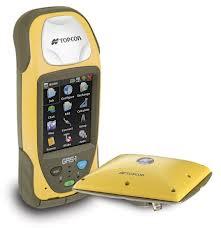
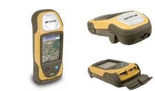
Topcon GRS-1 Hand-held Devices
RTK GNSS Receiver and Field Controller featuring 226 Channels with Universal Tracking
Topcon Positioning System’s GRS-1 (Geodetic Rover System) is an all-in-one handheld GNSS receiver and field controller featuring Topcon's exclusive Vanguard chip technology, compass and optional built-in camera. Other features include internal L1 antenna for GIS and navigation uses, internal modem and optional external antenna for GNSS network compatibility, or instantly change to dual constellation for centimeter accuracy RTK. Even use your GRS-1 as a static post-processed receiver solution.
Most importantly, the GRS-1 provides flexibility to fit you and your jobs by providing an SD memory card slot for up to 1GB Flash memory, optional internal GSM or CDMA modem, wireless LAN connectivity, and Bluetooth® wireless technology. The bright, high-contrast touch screen with virtual keyboard makes using Topcon's MAGNET or Pocket-3D software quick and easy.
Features include:
Vanguard chip technology featuring 226 Channels with Universal Channels
Internal GSM or CDMA Cellular Capability
806MHz XScale Processor
Windows Mobile® 6.1 Operating System
2.0 Megapixel Camera (optional)
256MB SDRAM, 1GB Flash
Internal Magnetic Compass
Built-in Bluetooth and Wireless LAN connectivity
Specifications
Tracking
Number of Channels 72 GPS + Glonass L1/L2, Universal Channels
WAAS/EGNOS Yes
CORS Beacon Yes with BR-1
Accuracy
DGPS Accuracy 50cm HRMS
L1, L2 Static Function H: RMS 3mm + 0.8ppm
V: RMS 4mm + 1.0ppm
Real time RTK Accuracy H: 10mm + 1.0ppm
V: 15mm + 1.0ppm
Software
Onboard Software TopSURV
Office Software (post processing) Topcon Tools™, SurveyMaster
Internal
Microprocessor XScale PXA320
Processor Speed 806MHz
Operating System Windows® Mobile 6.1
Data Update/Output Rate 1Hz – 100Hz Selectable*
Memory 256MB SDRAM
1GB Flash
USB Mini Port
Card Slot SD
GNSS Receiver GPS + GLONASS
Cellular Capability Internal GSM or CDMA**
Input/Output Bluetooth®, USB, Serial, ANT, and Power
Wireless LAN Connectivity Standard (Internal, 802.11.b)
Magnetic Compass Internal, 4 degree accuracy
Expansion Connector Weatherproof Communication Port
Battery Life 5 hrs while in GPS static mode
Battery Type 2500mAh Removable, Li-Ion Rechargeable
Physical
Dimensions 7.76” x 3.54” x 1.81” (197 x 90 x 46mm)
Weight 1.5 lbs (0.7kg)
Display 3.7” VGA LCD
Built-in Camera 2.0 Megapixel
Keyboard 3 Key plus Virtual Keyboard
Environmental
Waterproof IP66
Drop 1 meter
Operating Temperature -20° to 50°C
Operating with camera -10° to 50°C
Storage Temperature -30° to 60°C
$
3,696.00
Topcon GRS-1 for GIS
Don't give up the luxury of a small compact receiver with instantaneous positioning in order to increase your accuracy and functionality in the field. With an integrated cellular modem and Wireless LAN, Topcon's GRS-1 is the perfect solution for GIS users with high accuracy requirements who need real-time detail in the field but not a lot of headaches.
GRS-1 Features:
Submeter, Subfoot or “GIS-RTK” <5cm Accuracy
Internal GSM or CDMA Modem
Windows Mobile 6.1 Operating System
Integrated 2.0 Megapixel Camera
256MB SDRAM, 1GB Flash Memory
Built-in Bluetooth and Wireless LAN Technology
GNSS (GPS + Glonass) Satellite Receiver
A 72 channel dual frequency L1/L2 GPS receiver with an integrated cellular modem, the GRS-1 is an all-encompassing solution that grows and adapts with your project requirements. It can be used to dial up to a local reference station network for real-time corrections. No extra cell phone hardware is required. Use an external L1 antenna for real-time subfoot work. An external L1/L2 antenna is available for “GIS-RTK” (<5cm) work. Having a variety of accuracy capabilities available depending on the configuration of the unit makes the GRS-1 perfect for any GIS application including high accuracy projects such as utility infrastructure, underground electric and gas, water/wastewater, asset management, and land records management. There is no need to buy multiple products for multiple accuracies. The ability to dial up to a server while in the field allows users to upload and download GIS data directly to and from the database saving time and allowing for more immediate, detailed information.
The GRS-1 integrates an internal 2 megapixel autofocus digital camera to snap descriptive digital photographs. These photographs are automatically linked to GIS features so that no photo file manipulation is needed after the field work is complete. With 256MB of SDRAM and an 806MHz processor, the GRS-1 provides the fastest handheld performance on the market. It is loaded with memory (1GB Flash), but if needed, users can easily increase the memory for photo storage, maps or field data files by sliding an SD Memory card into the slot on the bottom of the GRS-1. With the GRS-1 the amount of detailed, accurate information that can be collected and stored is incredible. When combined with the lightweight small size of the system, the result is unprecedented.
$
3,336.00
Topcon Tesla RTK
GNSS Rover
The Topcon Tesla RTK is the largest screen handheld controller on the market that can also be utilized as a network RTK rover. This is the best controller to maximize the MAGNET Field user experience.
Using touchscreen technology, the Topcon Tesla RTK features direct touch access to all graphic controls. This 5.7” display is the main selling feature while the Windows 6.5.3 OS provides a modern operating environment and added expandability with other application software. The fast 806MHz processor drives any Topcon field application software with ease.
With the addition of a built-in 3.2MP camera, 3.5G cellular modem and Bluetooth® / WiFi ability, the Tesla RTK is an essential addition to any 3D measurement arsenal. Both Bluetooth® and WiFi are standard features of the new Tesla RTK eliminating the need for expensive upgrades. Devices can be used in a typical hotspot environment to connect to the internet and maximize the benefit of Magnet Enterprise.
Features:
Integrated RTK GNSS receiver
Large 5.7” VGA Color Touchscreen
Fast 806MHz processor
256MB RAM, 4GB flash storage
3.5G Cellular module
Built-in Bluetooth® and WiFi connectivity
Windows Mobile 6.5.3 Professional
Portrait or Landscape screen orientation
$
2,967.00
